The soil story changes dramatically depending on where you dig in Fort Wayne. A site near the confluence of the St. Marys and St. Joseph rivers often reveals silty alluvial deposits that feel greasy between your fingers, while a project out toward the higher ground of northwest Allen County hits glacial till packed with everything from clay-sized particles to cobbles. That difference matters. Without a complete grain size distribution curve from a sieve stack plus hydrometer analysis, you are guessing at how water moves through the formation and how the soil will compact under load. The city's legacy of river terrace deposits and Wisconsinan-age glacial drift means a single-point classification rarely tells the full story. For projects requiring permeability estimates or frost-susceptibility checks under Fort Wayne's seasonal freeze-thaw cycles, we pair the hydrometer data with Atterberg limits to confirm the clay fraction's behavior before the structural design leaves the desk.
A grain size curve that stops at the #200 sieve misses half the story in Fort Wayne's glacial soils — the clay fraction controls both drainage and frost heave.
Our approach and scope
Local geotechnical context
A mistake we see repeatedly around Fort Wayne is contractors submitting only a sieve analysis on a silty-clay fill and calling it clean sand because the fines washed through during wet-sieving. That shortcut backfires when the material is placed under a parking lot off Coldwater Road, and the first spring thaw turns the subgrade into pudding — trapped moisture with nowhere to drain because nobody measured the clay fraction below 75 microns. The hydrometer step is not optional for soils with more than 12 percent passing the #200 sieve; skipping it means the USCS classification stays incomplete, and the structural section gets designed for the wrong soil group. On one recent warehouse pad near the airport, we caught a gap-graded glacial deposit that looked fine on the sieve curve but had a missing middle fraction — the Cc value flagged it immediately. Fixing the subgrade before concrete went down cost a fraction of what a post-construction remediation would have run.
Reference standards
ASTM D6913-17 and ASTM D7928-21 are employed for grain size analysis via sieve and hydrometer methods, with ASTM D2487-17 governing the Unified Soil Classification System (USCS).
Complementary services
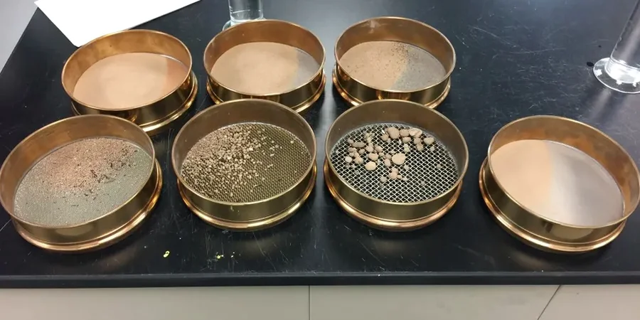
Full Sieve + Hydrometer Package
Mechanical sieving from 3 inches down to #200, followed by sedimentation hydrometer analysis for the minus-200 fraction. Delivered as a graded report with grain size distribution curve, Cu/Cc coefficients, and USCS classification per ASTM D2487.
Wash-Sieve Check (P200 Verification)
Targeted test for contractors who need quick confirmation of fines content before placing structural fill. We wash the sample over the #200 sieve, oven-dry the retained fraction, and report percent passing — same-day turnaround when the workload allows.
Soil Classification Package
Combines grain size analysis with Atterberg limits and moisture content to assign a complete USCS group symbol. Useful when Fort Wayne building officials request dual classification for foundation subgrade acceptance.
Typical parameters
Quick answers
Why do I need the hydrometer test if my soil looks sandy?
Many Fort Wayne sands contain a surprising amount of silt and clay that coats the grains and does not become obvious until the material gets wet. The hydrometer quantifies that fine fraction below 75 microns — if it exceeds 12 percent, the soil's engineering behavior shifts from granular to fine-grained, affecting everything from compaction to drainage. A visual classification alone misses this.
What does grain size analysis cost in Fort Wayne?
How much sample material do you need from the field?
For a complete analysis we ask for about 500 grams of fine-grained soil or up to 5 kilograms for granular material with gravel. The sample should be bagged to preserve natural moisture if you also want water content, and please avoid sampling from the very surface crust — the top few inches often dry out and do not represent the formation underneath.
How do I interpret the Cu and Cc coefficients on the report?
The uniformity coefficient (Cu) tells you whether the soil is well-graded or poorly-graded — values above 6 for sands indicate a good spread of particle sizes. The curvature coefficient (Cc) flags gap-graded soils, which are missing intermediate particle sizes and can compact unpredictably. For Fort Wayne glacial deposits, a Cc outside the 1-to-3 range is a red flag we always discuss with the geotechnical engineer before the material gets approved.