The most expensive mistake we see in Fort Wayne is treating every slope like it’s the same. A contractor cuts into what looks like stable ground along the St. Joseph River, assumes a standard 2:1 bench will hold through spring rains, and then watches the whole section slump after three days of thaw. The issue isn’t always the cut geometry — it’s the layered stratigraphy underneath. Fort Wayne sits on complex glacial sequences: tills over outwash sands, lacustrine silts wedged between gravel lenses, and weathered shale bedrock that degrades fast when exposed. A proper slope stability analysis has to account for perched groundwater, which is common in the till plains of Allen County, and for the loss of suction in silty soils during wet seasons. We combine field investigation with lab testing — measuring effective stress parameters from triaxial tests on undisturbed Shelby tube samples — to build models that actually represent what’s in the ground, not what the textbook assumes.
A slope that stands today can fail tomorrow — not because the soil changed, but because the pore pressure did. Fort Wayne’s spring thaw cycle makes this a predictable risk.
Our approach and scope
Local geotechnical context
The IBC 2021, referencing ASCE 7-22, requires slope stability evaluation whenever a structure is placed within a defined influence zone of a slope steeper than 15 feet in height. In Fort Wayne, that triggers for a surprising number of projects — not just riverfront developments along the Maumee, but also retention pond excavations in subdivisions, cut slopes for road widenings, and temporary shoring for sewer line installations. The local ordinance also ties into the Allen County Soil and Water Conservation District rules on erosion control, which means a slope failure that sends sediment into a regulated drain is both a geotechnical problem and a compliance violation. We’ve reviewed failures where the trigger was as simple as a downspout discharging uncontrolled at the crest, saturating the upper five feet of till over a weekend rain event. A proper analysis anticipates these scenarios — we model the fully saturated condition, not just the as-built geometry — and if the numbers don’t pencil out, we design reinforcement with anchors or regrade the profile before the first bucket of dirt moves. Waiting until the tension cracks appear at the crest is the most expensive way to do slope engineering.
Reference standards
Applicable standards incorporate the International Building Code 2021 and ASCE 7-22 for slope stability and seismic provisions, FH
Complementary services
Limit Equilibrium and Numerical Modeling
We build 2D cross-sections in Slide2 or GeoStudio using site-specific stratigraphy and lab-measured shear strength parameters. For critical slopes near infrastructure, we run finite element models that capture strain-softening and progressive failure — the kind of behavior that limit equilibrium misses. Each analysis includes a sensitivity study on pore pressure and a clear statement of factor of safety for static, seismic, and rapid-drawdown conditions.
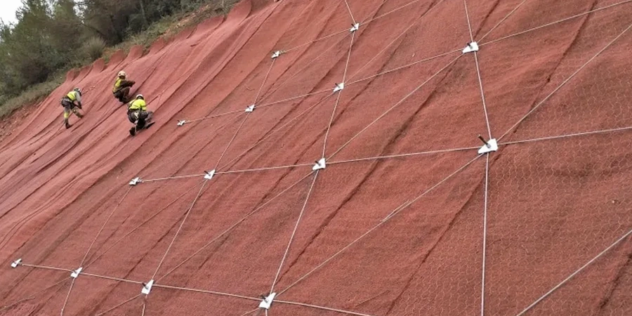
Remediation and Reinforcement Design
When the analysis shows insufficient factor of safety, we don’t just hand over a red-flag report. We design the fix: regrading recommendations, subsurface drainage systems to depressurize the slope, soil nail layouts, or anchored soldier pile walls with design calculations stamped by our geotechnical engineer. Everything is coordinated with Fort Wayne’s building department submittal requirements.
Typical parameters
Quick answers
What triggers a slope stability study requirement in Fort Wayne?
Typically, any slope over 15 feet in height within the influence zone of a proposed structure triggers the IBC requirement. Also, any cut or fill slope steeper than 2:1 on public projects, or slopes adjacent to regulated drains in Allen County, will require an analysis as part of the stormwater permit review.
How long does a typical slope stability analysis take?
For a typical residential or light commercial project, we can complete the field investigation, lab testing, and analysis in about three to four weeks. Larger projects with complex stratigraphy or projects requiring coordination with the Fort Wayne Plan Commission may extend to five or six weeks.
What’s the difference between limit equilibrium and finite element analysis?
Limit equilibrium divides the slope into slices and calculates force and moment equilibrium — it gives you a factor of safety. Finite element analysis models stress and strain throughout the slope and can capture progressive failure, where a local overstress redistributes and leads to a global collapse. We use LE for most projects and reserve FE for slopes with complex geology or where deformation predictions matter.
What’s the typical cost range for a slope stability analysis in Fort Wayne?
Can you analyze an existing slope that is showing signs of movement?
Yes — in fact, that’s one of our most common calls. We survey the tension cracks or scarps, install piezometers if groundwater is suspected, and back-analyze the failure to determine the operative shear strength. That gives us the parameters we need to design a stabilization solution that will actually work.